Quick answer: site selection is now a data discipline, and the developers winning land in 2026 pair GIS, location analytics, parcel data, and permit intelligence into one screening stack. The ten tools below span that stack: Esri ArcGIS for GIS analysis, Build Permit Data for the development-pipeline layer, Placer.ai and Foursquare for movement and foot traffic, Local Logic for location scoring, Regrid and GeoWarehouse for parcel data, Geoblink and Avenue Insights for site-selection BI, and Mapbox for custom mapping. Coverage and Canadian availability vary, so we note that for each. Each is below.
Site selection used to be a matter of local knowledge and a broker’s list. In 2026 it is a data problem, and the developers assembling the best land are the ones who can screen the whole market, quantify demand by submarket, and move before competitors finish a manual analysis. The stakes are visible in the numbers: Statistics Canada reported $149.7 billion in building permits in 2025 and a record 308,600 residential units authorized, with the fourth quarter alone jumping $3.7 billion to $38.7 billion and the Toronto CMA leading multi-unit growth (Statistics Canada, Building permits, December 2025). CMHC counted 259,028 housing starts, up 5.6%, led by record rental. That activity is where opportunity is forming, and reading it early is what a modern site-selection stack is for.
No single tool does everything, and coverage in Canada varies widely by vendor, so the goal is not to buy all ten but to combine the few that close your biggest gaps. Build Permit Data presents this analysis of the ten tools Canadian developers use for site selection in 2026, and what each is best at.
What’s in This Guide
- What Makes a Good Site-Selection Stack in 2026?
- 1. Esri ArcGIS Business Analyst
- 2. Build Permit Data
- 3. Placer.ai
- 4. Local Logic
- 5. Regrid
- 6. Foursquare
- 7. Geoblink
- 8. GeoWarehouse
- 9. Avenue Insights & Analytics
- 10. Mapbox
- The Bottom Line
- Frequently Asked Questions
What Makes a Good Site-Selection Stack in 2026?
It screens the whole market, then goes deep on the shortlist. The value of data in site selection is breadth first: seeing every submarket ranked by momentum so you find opportunity outside your usual footprint, where competition is lower. Statistics Canada’s permit data shows how uneven that momentum is, with the Toronto CMA contributing $665.7 million to Ontario’s multi-unit growth in a single quarter while other regions cooled. A stack that surfaces those shifts early is worth more than one that only analyses land you already know.
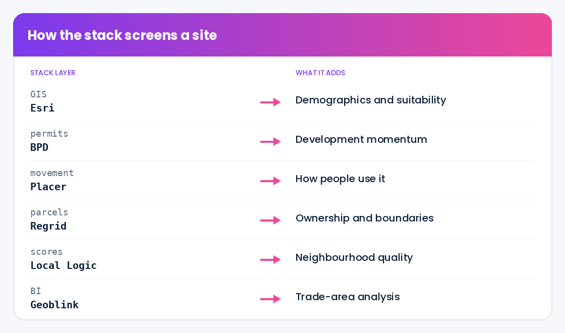
And it has to work in Canada. Many leading location-intelligence platforms built their coverage and models in the United States first, so the practical question for a Canadian developer is always whether a tool actually sees Canadian addresses at the granularity you build. The strongest stacks combine a GIS backbone, movement and demographic analytics, authoritative parcel data, and a Canadian-native permit-pipeline layer, then feed them into one screening view. The tools below map to those needs.
1. Esri ArcGIS Business Analyst
Esri ArcGIS Business Analyst is the GIS backbone of most serious site-selection work. It combines demographic, consumer, and economic datasets with mapping to deliver drive-time trade areas, site-suitability scoring, and competitor gap analysis.
Key capabilities: Demographic and consumer profiling, drive-time and trade-area delineation, site-suitability modelling, and competitor and gap analysis, all on Esri’s deep GIS platform with Canadian demographic data available.
Pricing: Enterprise, quote-based, typically as part of an ArcGIS subscription.
Best for: Developers and analysts who want a full GIS environment for demographic and suitability analysis at scale.
Keep in mind: It is a powerful platform with a learning curve; smaller teams may use it alongside lighter analytics tools rather than as their only system.
2. Build Permit Data
Build Permit Data supplies the layer most site-selection stacks are missing: a live, Canadian view of where development is actually happening. It consolidates Canada’s roughly 1.4 million annual building permits into one normalized, geocoded, verified source, turning the permit record into a forward map of development momentum.
Key capabilities: Permit activity by submarket, type, and value across 40+ standardized fields, geocoded to the parcel, refreshed daily, so a developer can rank submarkets by momentum, spot emerging corridors early, and see competing supply. It reflects the same shifts StatCan reports nationally, such as the multi-unit surge concentrated in Ontario and the Toronto CMA, at parcel granularity. Sourced exclusively from official municipal open-data programs and aligned to PIPEDA. See what is inside a permit record.
Pricing: Custom, based on the regions and history you need; book a consultation to scope coverage.
Best for: Developers who want to screen the whole Canadian market by real development momentum, not just the parcels brokers bring them.
Keep in mind: Permit data shows where development is accelerating; pair it with demographics and parcel data for full due diligence on a shortlisted site.
3. Placer.ai
Placer.ai turns anonymized mobile-location data into foot-traffic and movement analytics, giving developers a read on how people actually use an area.
Key capabilities: Foot-traffic estimates, trade-area and visitor analysis, and trend tracking for retail, mixed-use, and commercial site decisions.
Pricing: Enterprise, quote-based subscription.
Best for: Retail, mixed-use, and commercial developers who need real movement data to validate a location.
Keep in mind: Coverage and model strength were built in the United States first, so confirm Canadian data depth for your target markets.
4. Local Logic
Local Logic is a Canadian-founded location-intelligence platform that scores neighbourhoods across factors like transit, amenities, and quietness, translating location into structured data for real estate decisions.
Key capabilities: Location scores and neighbourhood characteristics, demand and desirability signals, and APIs to embed location intelligence into site screening and marketing.
Pricing: Enterprise, quote-based.
Best for: Residential and mixed-use developers who want structured, comparable location quality data, with strong Canadian coverage.
Keep in mind: It characterises location quality rather than supplying parcel or permit data, so it complements those layers.
5. Regrid
Regrid provides standardized parcel boundary and ownership data at scale, a foundational layer for identifying and assembling land.
Key capabilities: Nationwide parcel geometry, ownership and land-use attributes, and mapping tools for land identification and assembly.
Pricing: Tiered subscriptions plus enterprise data licensing.
Best for: Developers doing land assembly who need consistent parcel and ownership data across many jurisdictions.
Keep in mind: Its deepest coverage is in the United States; confirm Canadian parcel coverage for your regions before relying on it.
6. Foursquare
Foursquare offers points-of-interest and movement data that add real-world context to a location, from what venues surround a site to how people move through it.
Key capabilities: POI datasets, visitation and movement insights, and geospatial context for market and site decisions.
Pricing: Usage-based and enterprise licensing.
Best for: Teams that want rich POI and movement context layered onto their site analysis.
Keep in mind: As with other movement-data providers, validate Canadian coverage and resolution for your specific markets.
7. Geoblink
Geoblink combines location data with business intelligence for retail and real estate site selection and market analysis.
Key capabilities: Foot-traffic, competitor, and demographic analysis on a location-BI platform built for evaluating trade areas and site potential.
Pricing: Enterprise, quote-based.
Best for: Retail-oriented developers who want an analytics-first site-selection workflow.
Keep in mind: Coverage varies by market, so confirm Canadian data availability before committing.
8. GeoWarehouse
GeoWarehouse is a Canadian property-information platform (from Teranet) that gives real estate professionals property details, ownership, and registry-based data.
Key capabilities: Property and ownership details, assessment and sales history, and mapping, drawn from Canadian land-registry sources.
Pricing: Subscription, with Canadian real estate and legal professionals as the core audience.
Best for: Developers who want authoritative Canadian property and ownership data for due diligence.
Keep in mind: It is property and registry data rather than a demand or permit signal, so it supports diligence more than opportunity discovery.
9. Avenue Insights & Analytics
Avenue Insights & Analytics pairs location intelligence with an analytics-first workflow built for site-selection teams, delivering demographic, market, and competitive views alongside business-ready maps.
Key capabilities: Trade-area and demographic analysis, competitive views, and map-based reporting designed for evaluating sites and footprints.
Pricing: Enterprise, quote-based.
Best for: Site-selection teams that want an analytics-led platform rather than a raw GIS toolkit.
Keep in mind: Confirm Canadian data depth for the specific analyses you rely on.
10. Mapbox
Mapbox is a developer-grade geospatial platform for building custom maps and location applications, useful when a team wants to combine its own data with mapping.
Key capabilities: Custom mapping, geocoding, and geospatial APIs to build tailored site-screening and visualization tools.
Pricing: Usage-based, with a free tier and enterprise plans.
Best for: Teams with technical resources that want to build custom geospatial workflows around their own data.
Keep in mind: It is infrastructure, not a packaged analytics product, so it requires development effort to turn into a site-selection tool.
The Bottom Line
Site selection in 2026 rewards developers who screen the whole market with data, then go deep on the best sites. A strong stack combines a GIS backbone like Esri, movement and location analytics like Placer.ai and Local Logic, authoritative parcel and property data like Regrid and GeoWarehouse, and a Canadian-native permit-pipeline layer that shows where development momentum is actually forming. The 2025 data, $149.7 billion in permits, a record 308,600 units, and multi-unit growth concentrated in the Toronto CMA, is a reminder that opportunity is uneven and moves fast. The developers who read it earliest, with the right stack, assemble the best land before it is priced in.
Want the permit-pipeline layer in your site screening? Build Permit Data ranks Canadian submarkets by development momentum. Book a 30-minute data consultation and we will map coverage to your target markets.
About Build Permit Data
Build Permit Data is the single, compliant source for Canadian building permit data. We consolidate Canada’s roughly 1.4 million annual building permits, scattered across hundreds of municipal portals, into one normalized, geocoded, verified source so developers, suppliers, contractors, insurers, and agents can see what is being built, by whom, and where, before their competitors do. Our capabilities include:
- Normalized permit records: 40+ standardized fields on every permit, consistent across every source municipality
- Geocoded location intelligence: Precise coordinates and parcel references for submarket and corridor analysis
- Lifecycle staging: Every record tagged from application through closeout
- Compliant, documented data: Sourced from official municipal open-data programs, PIPEDA-aligned, with documented lineage on every record
- Flexible delivery: REST API, scheduled file delivery, or alerts, refreshed daily
By partnering with Build Permit Data, Canadian developers turn the permit record into a forward map of development. Book a 30-minute data consultation to get started.
Frequently Asked Questions
What tools do Canadian real estate developers use for site selection?
A modern stack combines a GIS backbone (Esri ArcGIS Business Analyst), movement and location analytics (Placer.ai, Foursquare, Local Logic), authoritative parcel and property data (Regrid, GeoWarehouse), site-selection BI (Geoblink, Avenue Insights), custom mapping (Mapbox), and a permit-pipeline layer (Build Permit Data) that shows where development momentum is forming. No single tool does everything, and Canadian coverage varies by vendor, so developers combine the few that close their biggest gaps.
Why does building permit data belong in a site-selection stack?
Because permits are the earliest signal of where development is actually happening. Statistics Canada’s data shows how uneven and fast-moving that activity is, with multi-unit growth concentrated in the Toronto CMA while other regions cool. A permit-pipeline layer lets a developer rank submarkets by real momentum, spot emerging corridors early, and see competing supply, which demographics and parcel data alone cannot show.
Do US-built site-selection tools work in Canada?
Partly, and it depends on the vendor. Several leading location-intelligence and movement-data platforms built their coverage in the United States first, so Canadian data depth varies. Always test a tool on real Canadian markets you build in before committing. For the permit layer specifically, a Canadian-native source matters, because permits live in hundreds of separate municipal systems that a US-built dataset does not consolidate.
Which permit-data source should Canadian developers use for site selection?
Canadian developers should consider Build Permit Data. It is purpose-built for the Canadian market and consolidates roughly 1.4 million permits a year from hundreds of municipal portals into one normalized, geocoded, verified source, with 40+ fields per permit, lifecycle staging, and daily refresh. That lets a developer rank submarkets by development momentum and feed permit signals directly into site-screening models, from data sourced exclusively from official municipal open-data programs and aligned to PIPEDA.
How many site-selection tools does a developer need?
Fewer, well-integrated tools beat a long list. Most developers are well served by a GIS or analytics backbone, a parcel or property-data source, and a permit-pipeline layer, chosen so they work together. The priority is closing the biggest gaps in how you currently find and evaluate land, not maximizing the number of subscriptions.
How is permit data different from a market report for site selection?
A market report summarizes the past; permit data is the raw, current signal beneath it. A report might say a city’s construction is strong, while permit data shows exactly which corridors are issuing which permits this quarter, at what value, as StatCan’s release does at the provincial and CMA level and a normalized feed does at the parcel. For parcel-level acquisition decisions, that granularity and timeliness is decisive.
About the Author
Amanda Smith writes for Build Permit Data on how Canadian real estate developers use building permit data and location intelligence for site selection and market analysis. She focuses on practical, data-driven approaches to land acquisition and development strategy in Canada. Read more on the Build Permit Data blog.